Log in
All resources
Create a design
10,904 Free Images of Engraved Maps
baroque
engravings of topographia braunschweig lüneburg
national library of poland
map of amsterdam by julius milheuser after daniël stalpaert, 1662
julius milheuser
copper engraving print
engravings of castles in lower saxony
british library
joan blaeu
university of texas at arlington
1841 maps of the united states
maps by george w. boynton
1803 in berlin
1803 maps
maps from the earth and its inhabitants, vol. vi
latin-language maps
atlas ou representation du monde universel t. 2 (1633)
old maps of the republic of genoa
atlas ou representation du monde universel t. 2 (1633)
maps by hendrik hondius the younger
engravings of topographia braunschweig lüneburg
baroque
eran laor cartographic collection
pierre françois tardieu
claes jansz. visscher (ii)
atlas van stolk
atlas maior, vol 10 (spain and africa) - joan blaeu, 1667 - bl 114.h(star).10
1667 maps
1830 maps of the united states
maps by george w. boynton
maps of the dutch east india company - indonesia
18th-century maps of java
eran laor cartographic collection
engravings by frans hogenberg
maps of paris by braun & hogenberg
georg braun
theatri praecipvarvm totivs mvndi vrbivm : liber sextvs (1618)
maps of york by braun & hogenberg
theatri praecipvarvm totivs mvndi vrbivm : liber sextvs (1618)
maps of heilbronn by braun & hogenberg
johann david schleuen
old maps of prussia
eran laor cartographic collection
jacques-philippe le bas
wienhausen monastery
baroque
engravings of topographia braunschweig lüneburg
baroque
maps by pieter mortier
indochina
de praecipvis totivs vniversi vrbibvs, liber secvndvs (1575)
maps of wissembourg by braun & hogenberg
juan de la cruz cano y olmedilla
maps by tomas lopez
atlas maior, vol 10 (spain and africa) - joan blaeu, 1667 - bl 114.h(star).10
1667 maps
engravings by romeyn de hooghe
engravings by jan luyken
miniature speed atlas (1627) pieter van den keere
county maps of england by john speed
maps by willem and johannes blaeu
1635 maps of africa
1600s maps of the netherlands
1609 maps of europe
engravings of topographia braunschweig lüneburg
baroque
maps of brno by braun & hogenberg
1617 engravings
1803 in berlin
1803 maps
topographia westphaliae (merian)
baroque
düsseldorf in the 1800s
old maps of düsseldorf
maps of the divisions of the polish-lithuanian commonwealth
karol de perthées
engravings of topographia braunschweig lüneburg
baroque
engravings of topographia braunschweig lüneburg
baroque
köln-weidenpesch
köln-nippes
st thomas' hospital (southwark)
guy's hospital
maps of barbary coast by mercator-hondius
maps by jan janssonius
map of bruges by marcus gheeraerts (i)
drawings in the groeningemuseum
maps by louis brion de la tour
1761 maps of africa
maps of barbary coast by mercator-hondius
maps by jan janssonius
atlas van der hagen (volume 2)
atlas van der hagen
engravings of topographia braunschweig lüneburg
baroque
engravings by romeyn de hooghe
engravings by jan luyken
vrbivm praecipvarvm totivs mvndi (1612)
maps of dokkum by braun & hogenberg
maps of helsingborg by braun & hogenberg
vrbivm praecipvarvm totivs mvndi (1612)
maps by willem and johannes blaeu
copper engravings
map of amsterdam by julius milheuser after daniël stalpaert, 1662
julius milheuser
map of amsterdam by julius milheuser after daniël stalpaert, 1662
julius milheuser
map of amsterdam by julius milheuser after daniël stalpaert, 1662
julius milheuser
map of amsterdam by julius milheuser after daniël stalpaert, 1662
julius milheuser
map of amsterdam by julius milheuser after daniël stalpaert, 1662
julius milheuser
moïse-jean-baptiste fouard
corsair wars
petit atlas pittoresque des 48 quartiers de la ville de paris, david rumsey historical map collection
maps of paris from the david rumsey historical map collection
1841 maps of the united states
maps by george w. boynton
atlas maior, vol 2 (sweden, russia, poland, eastern europe, and greece) - joan blaeu, 1667 - bl 114.h(star).2
old maps of macedonia
atlas maior, vol 5 (england) - joan blaeu, 1667 - bl 114.h(star).5
17th-century maps of yorkshire
maps from the earth and its inhabitants, vol. xv
19th-century maps of british columbia
maps from the earth and its inhabitants, vol. xv
19th-century maps of british columbia
maps of barbary coast by mercator-hondius
conquest of majorca
civitates orbis terrarvm, liber primvs (1577)
maps of diu by braun & hogenberg
civitates orbis terrarvm, liber primvs (1577)
maps of nuremberg by braun & hogenberg
maps of the dutch east india company - sri lanka
1750
festung lichtenau
baroque
turgot map of paris – derivative files
old maps of île saint-louis
historical
history
1858 van de velde maps of palestine and jerusalem
1850s maps of lebanon
festung lichtenau
baroque
map of amsterdam by julius milheuser after daniël stalpaert, 1662
julius milheuser
map of amsterdam by julius milheuser after daniël stalpaert, 1662
julius milheuser
map of amsterdam by julius milheuser after daniël stalpaert, 1662
julius milheuser
map of amsterdam by julius milheuser after daniël stalpaert, 1662
julius milheuser
map of amsterdam by julius milheuser after daniël stalpaert, 1662
julius milheuser
engravings of topographia braunschweig lüneburg
baroque
engravings of topographia braunschweig lüneburg
baroque
engravings of topographia braunschweig lüneburg
baroque
engravings of topographia braunschweig lüneburg
baroque
maps from the earth and its inhabitants, vol. viii
buddhist pilgrimage sites in india
maps from the earth and its inhabitants, vol. xv
maps indicating exploration
old maps of south africa
maps of the great trek
maps from the earth and its inhabitants, vol. vii
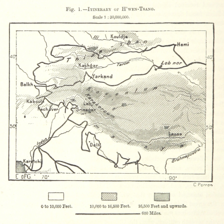
maps of xuanzang's travels
maps from the earth and its inhabitants, vol. xiii
ethnographic maps of africa
maps from the earth and its inhabitants, vol. iv
old maps of newcastle upon tyne
maps from the earth and its inhabitants, vol. viii
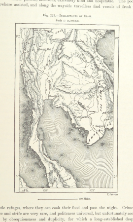
demographic maps of thailand
maps from the earth and its inhabitants, vol. iv
maps of portland, england
maps from the earth and its inhabitants, vol. iv
maps of kirkwall
the gazetteer of scotland (1838)
william home lizars
atlas maior, vol 2 (sweden, russia, poland, eastern europe, and greece) - joan blaeu, 1667 - bl 114.h(star).2
17th-century maps of finland
atlas maior, vol 5 (england) - joan blaeu, 1667 - bl 114.h(star).5
17th-century maps of norfolk, england
maps by pieter mortier
indochina
jan karel donatus van beecq
hernán cortés
maps from the earth and its inhabitants, vol. xv
19th-century maps of british columbia
maps of exeter by braun & hogenberg
hooker (alias vowell) arms
maps of bergen (norway) by braun & hogenberg
1580s engravings
speculum romanae magnificentiae (mirror of roman magnificence)
sebastiano del re
cetus (constellation) in art
uranometria
atlas ou representation du monde universel t. 2 (1633)
maps by hendrik hondius the younger
maps of brno by braun & hogenberg
1617 engravings
engravings of topographia braunschweig lüneburg
baroque
1600s maps of the world
copper engravings
1701 - 1800 of 10,904
Next page
/ 110


![Gerardi Mercatoris and I. Hondii Atlas or Representation of the Universal World, and of the Parts of It, Made in Tables and Very Ample Descriptions. [t. 2].](https://cdn.creazilla.com/illustrations/10000735247/gerardi-mercatoris-and-i-hondii-atlas-or-representation-of-the-universal-world-and-of-the-parts-of-it-made-in-tables-and-very-ample-descriptions-t-2-sm.webp)
![Gerardi Mercatoris and I. Hondii Atlas or Representation of the Universal World, and of the Parts of It, Made in Tables and Very Ample Descriptions. [t. 2].](https://cdn.creazilla.com/illustrations/10001261552/gerardi-mercatoris-and-i-hondii-atlas-or-representation-of-the-universal-world-and-of-the-parts-of-it-made-in-tables-and-very-ample-descriptions-t-2-sm.webp)


![Barbarie [Barbaria, Carthaginensis Sinus, Aegyptus], 1633](https://cdn.creazilla.com/illustrations/10001157360/barbarie-barbaria-carthaginensis-sinus-aegyptus-1633-md.jpg)